East Jerusalem
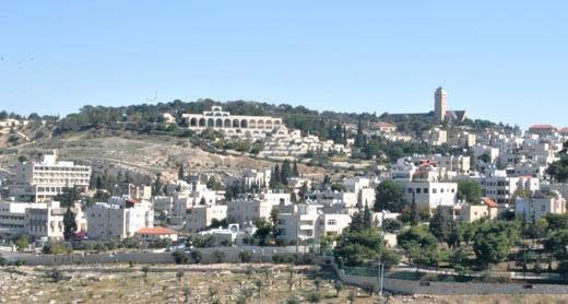
A national park to include areas of East Jerusalem was first declared in 1974. This would be Jerusalem Walls Park, spanning an area of roughly 110 hectares, more than half of it in East Jerusalem. The park encircles the Old City walls and includes extensive populated areas of the Palestinian neighborhood of Silwan. Local master plan no. 6, approved by the Jerusalem Municipality in 1970, designated this land for a national park designed to preserve "the character and nature of the area, by preserving the landscape as well as historical, national, religious, traditional, archeological and architectural values, picturesque ensembles and landscape values […] and also development and cultivation of the area so as to offer the general public the comfort and convenience necessary for conducting tours and spending time in the area". In articulating these goals, the city planners ignored the fact that this was the only national park whose land includes densely populated residential neighborhoods, as well as industrial, commercial and recreational areas. The park encompasses nearly all of the Wadi Hilwa neighborhood in Silwan, south of the Old City walls. Wadi Hilwa is home to approximately 4,000 residents who living in more than 700 residential units in over 250 buildings. The City of David archeological site, which includes the ancient city of Jerusalem, is located in the very heart of the neighborhood. Designating this area as a national park creates a direct conflict between preservation requirements and the population’s need for construction and development, which cannot be met due to the planning limitations entailed by the declaration of the park. In a meeting on this issue held at the Ministry of Environmental Protection in 2003, Architect Uri Shitrit, Jerusalem City Engineer at the time, recognized these difficulties, stating that, “Construction and planning laws are in constant conflict with the National Parks Law inside the national park. There’s a real problem with the management of a national park […] versus the need to ensure continued urban development as well as maintenance of a vibrant and sound city life in the Old City and its environs”. Wadi Hilwa in Silwan, incorporated in national park. Photo: Keren Manor, Activestills, 15 May 2014 Because of the park’s unique location, and unlike its conduct with regard to other national parks located inside the jurisdiction of a municipality, the Nature and Parks Authority has delegated powers to the Jerusalem Municipality that allow it to operate and develop the park. Consequently, this park is jointly run by the two bodies. The City of David site was kept out of this agreement and the Nature and Parks Authority was to retain exclusive authority over its administration. However, , ever since 1997 the City of David site has been run by an Israeli NGO called El-Ad (acronym for “To the City of David” in Hebrew), making it the only national park in Israel to be operated by an organization whose aim is to promote a particular ideology. The decision to entrust the City of David to El-Ad was made contrary to the position of the Israel Antiquities Authority, namely that the site should be operated by the Israel Nature and Parks Authority. El-Ad operates the visitor center in the heart of the Wadi Hilwa neighborhood and funds excavations in various locations in Wadi Hilwa. El-Ad has also initiated a plan for the Kedem Center, a tourist compound for the entire national park and the Old City. Construction of the center was approved in April 2014 and El-Ad is slated to run it. El-Ad also engages in acquiring houses and lots in Silwan and installing Jewish inhabitants there. El-Ad does so in pursuit of its goal of “strengthening the Jewish bond to Jerusalem”. Since the 1990s El-Ad and other organizations have arranged for 60 Jewish settler families, totaling some 300 individuals, move into the neighborhood. El-Ad has also submitted a plan for building 200 residential units near the City of David site. The plan was rejected. Wadi Hilwa: No planning coupled with ban on construction Local master plan no. 9, approved by the Jerusalem Municipality in 1976, two years after the national park was declared, zones the entire area of Wadi Hilwa as “special open area”. The plan prohibits any construction of residential or public buildings in the area. Any other activity or use of the area requires special approval from the municipal planning authorities. The plan exempted existing structures, but allowed their expansion only for the purpose of improving sanitation. In contrast, the plan zones the neighborhood of Yemin Mosheh, also located within the national park but inside the Green Line, as a “special residential area”, allowing construction of residential and public buildings, subject to preservation considerations and design of the area. In his book, published in 1973, Arieh Sharon, the head of the planning team that prepared Plan no. 9, described Wadi Hilwa as an “unremarkable neighborhood with many ugly houses”, that sprang up in an area of great archeological importance. Sharon argued that evacuating and then resettling residents of the neighborhood would be too costly. He therefore suggested that the neighborhood be liquidated over time, as part of a long term policy that would not authorize construction of new buildings and would gradually purchase lots and resettling families in other areas. In practice, the Jerusalem Municipality does not evict families from Wadi Hilwa, but neither does it allow lawful construction in the neighborhood. Owing to this policy, almost all construction in the neighborhood, including tourism facilities and the settlers’ dwellings, has been carried out without permits. Residents suffer from a severe shortage of residential and public buildings. The neighborhood has only one girls’ school – it is run by UNRWA and serves as both elementary and junior high school, one private boys’ school (elementary school, two classes) and one private pre-school. The vast majority of the neighborhood’s children are obliged to go to other neighborhoods to attend schools. Wadi Hilwa has no medical clinics, post offices or public parks. Over the years, residents have attempted to promote building plans that would allow construction in the neighborhood, but all were rejected. Since 1967, hundreds of Wadi Hilwa’s residents have been convicted of building unlawfully and ordered to pay fines ranging from thousands to tens of thousands of shekels. According to figures obtained by B’Tselem, since 2006, the Jerusalem Municipality has demolished a total of 15 homes in Silwan, including in Wadi Hilwa. February 2012 saw the first time the Nature and Parks Authority demolished a structure in the neighborhood - a community center and a playground funded by the neighborhood’s residents themselves and built on private land owned by a Silwan resident. The site was used by approximately 300 children for sporting and social activities. Since no other public spaces are available in the neighborhood, it was also the venue for public events. In 2007, the Jerusalem Municipality initiated a master plan for the Wadi Hilwa area and the slopes of Mount Zion. The plan was prepared without involving the Palestinian residents. On the other hand, El-Ad was made party to the planning process and even contributed funds to it. The plan designates 70% of the area for parking lots, parks, and antiquity sites, as well as the preservation of open spaces, in an effort to further develop tourism in accordance with area’s purported objectives. The plan includes the first ever proposal to zone land inside the neighborhood for residential purposes, giving retroactive approval to most of the existing buildings, both Palestinians’ and settlers’. The plan, however, offers no solution for the residents’ other needs, either now or in the future. While the Israel Nature and Parks Authority does admit that, “the current situation, wherein thousands of residents live in hundreds of unregulated structures is intolerable on every level”, it argues that “allocating areas inside a national park for residential use […] may attract new plans for construction inside this and other national parks”. To advance this plan, some areas must re-designated so as to fall outside the national park in a process open to veto by many actors, including the Minister of Interior, the Minister of Environmental Protection and the Knesset Internal Affairs and Environment Committee. However, this was not done and though the plan was approved by the local committee in November 2007, it was not moved forward since and was officially shelved in March 2014. Tourism Development in Wadi Hilwa/The City of David From 2005 to 2013, the Israeli government and the Jerusalem Municipality budgeted a total of more than half a billion shekels for the “restoration, development and maintenance of the Old City and Mount of Olives Mount basin”. In May 2012, the government budgeted an additional 350 million shekels [approx. 100 million USD] for “continued development of public-tourist space in Jerusalem” in 2013-2019. A portion of these funds is used to develop tourism in Silwan, including budgetary funds the Ministry of Tourism transfers to El-Ad. Development of tourism in the neighborhood is harmful to its residents, disrupting their daily lives. Owing to construction of the visitor center and the various excavation sites in the very heart of Wadi Hilwa have resulted in inaccessibility to residents of some 25% of its open spaces. Entry to these areas involves a security check, and in some cases, a fee. Unlike other national parks in close proximity to residential areas, Wadi Hilwa residents do not have free access to the City of David site. The City of David visitor center compound was built in an area that has a number of Palestinian houses. Residents suffer from litter left behind by visitors, the spotlights used at the site at night, and parking problems. Hundreds of tourists arrive at the center every day in buses which cause traffic congestion in the narrow streets of the crowded neighborhood. On occasion, the visitor center also hosts special events, and traffic is not permitted on adjacent streets as part of security measures for the event. The security arrangements instituted for the benefit of the settlers and the tourist sites include the installation of dozens of surveillance cameras in the neighborhood. Additionally, dozens of armed security guards, carrying loud communication devices, were posted there with Ministry of Housing funding. The cameras violate residents’ privacy and the presence of security guards and settlers results in friction and conflict with the Palestinian residents, including children. In 2008, Israeli authorities decided on a 30-million-shekel infrastructure development project in the neighborhood to facilitate visitor access to tourist sites and to make its streets more attractive. The plan included new traffic arrangements, expansion and paving of sidewalks, building parking lots on 13 lots owned by Palestinians in the neighborhood, restoration of house facades, as well as sewage and electrical projects. Because the neighborhood has no master plan, authorities began carrying out the project without building permits and without giving public notice of the plan, as required by law, thereby denying residents the opportunity to review the plan and voice their views on it. Implementation would likely have exacerbated traffic congestion in the neighborhood, and cancelled hundreds of parking spaces along the streets, forcing residents to park in distant parking lots accessible by steep roads, or in lots close to the tourist sites, which are filled with visitors’ vehicles during the day. The decision to convert vacant lots in the neighborhoods into parking lots blatantly disregards the residents’ pressing need for educational facilities and other public buildings, as well as their need for public parks. In July 2011, following a petition to the District Court – filed on behalf of Wadi Hilwa residents by Israeli human rights NGO Bimkom and the Association for Civil Rights in Israel – and a subsequent to an appeal to the Supreme Court regarding the District Court’s ruling, the Supreme Court instructed the state to re-examine traffic arrangements and dismantle the additions that had been built without permits. As of June 2014, the previous situation has not been restored. An appeal filed by residents against the municipality’s decision to build parking lots in open spaces in the neighborhood was dismissed by the Supreme Court in December 2011. Entrance to Pool of Siloam. Photo: Keren Manor, Activestills, 15 May 2014 Archeological excavations in open spaces and under houses El-Ad finances the archeological excavations by the Israel Antiquities Authority in various parts of Wadi Hilwa. The digs take place in the neighborhood’s few remaining open spaces, which are then sealed off to residents in a manner that excludes them and bolsters Israeli presence in the area. A path used by residents of Silwan’s al-Bustan neighborhood to reach the mosque and the pre-school they use in Wadi Hilwa was closed off due to the excavation at the Shiloah Pool, (also known as the Pool of Siloam). The path was incorporated into the tourist site which charges a fee for access. Um a-Daraj/Gihon Spring, located in one of the few open spaces in the neighborhood, had traditionally served as a recreational spot for local residents, but they have been unable to access it since 1995, when an archeological dig (Beit Ha’Ma’ayan) began at the site. In January 2014, El-Ad submitted a plan for a tourist center at there, despite the fact that the area is not part of the City of David compound. The plan includes retroactive approval for a large structure – already in use by El-Ad for tourism – built without a permit on top of the excavation, additions to existing structures and preparing land for tourism in the area. In addition to the excavations in open spaces in the neighborhood, horizontal tunnels are being dug in Silwan, partly running under the homes of Palestinian residents, and without their consent. According to experts, archeologists abandoned the practice of digging horizontal tunnels as long as a century ago. It is considered professionally unethical and actually leads to the destruction of antiquities. Palestinian families living above these excavation sites report damage to their property, including cracks in the walls, floors caving in and sinkholes in the roads. The tunnels are designed to be used by visitors as underground archeological trails leading from the Shiloah Pool, through Givati Parking Lot to the Western Wall compound and from the visitor center to the Givati Parking Lot. These underground tours frame the connection between the City of David and the Old City in terms that create an illusion of an exclusively Jewish space without a trace of the region’s Palestinian residents and their history. It stands to reason that El-Ad presents the findings unearthed in the excavations in a way influenced by its ideology. El-Ad presents a historical account of ancient Jerusalem that highlights the First Temple period and attempts to link the findings to the biblical story of King David. This link, a matter of controversy among archeologists, is framed as proof of the historic right of the Jewish people – and the State of Israel – to the area. El-Ad shapes public consciousness of the site as exclusively Jewish, minimizing the importance of the city to other religions and cultures. It makes little reference to either archeological findings that do not fit its narrative or the Palestinian neighborhood and its residents. In so doing, the national park becomes another tool for promoting El-Ad’s goals. Kedem Center. Photo: Keren Manor, Activestills, 15 May 2014 The Kedem Center – Givati Parking Lot The place known as Givati Parking Lot is an open space located across from the City of David visitor center, near the road that encircles the Old City walls. The Jerusalem Municipality began using the space as a parking lot in the 1970s, following an agreement with its owner. The lot was subsequently officially expropriated. Local residents used the lot for parking, sports activities and events until excavations began there in 2003. Sometime after that, El-Ad purchased the land from its Palestinian owner. Although, formally, the area was appropriated by the Jerusalem Municipality, the municipality ignores it and is uninvolved in what is done on that site. In 2009, El-Ad proposed a plan for a large tourist center at the excavation site. The Nature and Parks Authority then became a party to submitting plan. The plan includes construction of a seven-story building, almost as tall as the Old City walls. This contravenes the planning provisions of the national park, which include the instruction not to build structures that would “compete” with the walls. The proposed building, to be named the Kedem Center, will include an archeological exhibit, a tourist section, a parking lot and underground tunnels leading to the Western Wall and the City of David. El-Ad is to run the center, even though it is not part of the City of David compound which is under the organization’s charge. The Kedem Center is designed to serve as the main tourist route for the entire area, with the aim of significantly increasing the number of visitors. The Jerusalem District Planning Committee of the Ministry of Interior discussed the plan at a meeting in February 2012. Jerusalem Mayor Nir Barkat, who attended the committee’s meeting, said: “The City’s goal is to lay down the infrastructure to accommodate about ten million visitors per year” and “The Kedem Center plays a large and important role in creating this infrastructure, given its convenient location in a central part of the national park and the ancient city and the high quality of the site itself […]”. The committee approved the plan, despite the universal prohibition on construction in the area and despite the great proximity to the Old City walls, which the Jerusalem Walls National Park is designed to protect. In May 2012, the government announced the establishment of a museum and academic center devoted to the Old Testament inside the Kedem Center to be named “The Bible Hall”. The Kedem Center project is a source of controversy among archeologists. It was advanced through a questionable planning process and without any discussion about the needs of the local residents. In October 2013, Israeli Prime Minister Benjamin Netanyahu ordered the plan to be deposited for objections. His decision to promote the Mount Scopus Slopes National Park - another tourism project designed to strengthen the Jewish foothold in Palestinian areas in Jerusalem – was announced at the same time. These decisions, like other decisions to promote various building plans intended to serve Jewish communities beyond the Green Line, were made public immediately after Israel released Palestinian prisoners, in an effort to appease right wing discontent over the release. Several objections were filed after the plan was deposited, including one by a number of public figures. Nevertheless, the Jerusalem District Planning Committee approved plan was in April 2014, subject to certain conditions, including that the structure not extend above the level of the upper road by the foot of the wall. According to plan, the Kedem Center was to cover an area of 1.6 hectares, an area that could have been used to build the public facilities so desperately needed by Silwan residents. The center will deliberately overshadow the Palestinian neighborhood surrounding it, expand Israeli access to Silwan and Israeli presence in the neighborhood, and will also bolster El-Ad’s standing in the area. Situating the center directly at the northern entrance to Wadi Hilwa may result in even greater traffic congestion and impede residents’ access to their homes. The presence of the compound would boost the image of the neighborhood as an archeological tourist site, while Palestinian presence there is ignored. In June 2014, the NGO Emek Shaveh: Archeology in the Shadow of Conflict appealed the plan’s approval. In June 2015, the sub-committee of the National of the National Planning and Construction Committee responded to the appeal. The sub-committee okayed the plan for a visitor center in the area, but ruled its size should be reduced by half. The sub-committee also made a precedential ruling that the construction permit would be subject to the publication of a conservation plan the Antiquities Authority would prepare once the excavation at the site is completed, so that the public can respond. The sub-committee returned the plan for the Kedem Center to the District Committee. Harm to other neighborhoods Abu Tur: The Jerusalem Municipality uses the Year 2000 Jerusalem Master Plan as a guideline for city planning, despite the fact that it has not yet gone into effect (See also here). Israeli NGO Bimkom has uncovered an earlier version of the plan, which allocates more lands to the Jerusalem Walls National Park than does Plan No. 6. The additional area includes a bloc of 2 hectares bordering the built-up part of the Abu Tur neighborhood. A few years ago, the Nature and Parks Authority built a scenic observation post there, despite the fact that it was not officially part of the national park. In December 2011, the Jerusalem Municipality demolished an agricultural structure on the site and uprooted about ten old olive trees. The director of the Jerusalem District at the Nature and Parks Authority was present at the demolition. Abu Tur, a densely built neighborhood, has no remaining land reserves for development. The site in question is particularly suitable for public use by neighborhood residents, either as a school or as a public park, since the terrain is flat and adjacent to the main road. However, the apparent plan to incorporate this land into the national park may obstruct this possibility. Wadi al-Joz: The Jerusalem Walls National Park covers an area of 5.6 hectares, not immediately adjacent to the Walls, in the south-east part of the Wadi al-Joz neighborhood. Local residents use this area for a market and for parking. There are also a number of residential buildings located three. The fact that the area is defined as a national park precludes further building and development there, despite local residents' pressing need for land to build on. The neighborhood has planned areas with a small percentage of building allocation and unplanned areas that are built densely. Sources: Bimkom, East Jerusalem Survey (updated Hebrew version). Bimkom, From Public to Nations – National Parks in East Jerusalem, 2012, pp. 14-21. Bimkom, Expert Opinion on Planning, in AP 8938/08 Salim Siam v. Jerusalem Municipality, July 2009 [Hebrew]. Emek Shaveh, From Territorial Contiguity to Historical Continuity: Asserting Israeli Control through National Parks in East Jerusalem – Update 2014 (see section on Kidron) Emek Shaveh, Remaking the City: Archaeological Projects of Political Import in Jerusalem’s Old City and in the Village of Silwan [Hebrew original published November 2013]. Emek Shaveh, Another Future for Antiquities, Conservation of Antiquities Sites: Suggestions towards a Partial Solution of Jerusalem’s Political Problems [Hebrew original published November 2013]. Emek Shaveh, From Silwan to the Temple Mount: Archaeological Excavations as a Means of Control in the Village of Silwan and in Jerusalem’s Old City – Developments in 2012 [Hebrew original published February 2013]. Emek Shaveh, “Beit Haliba” and the Givati Parking Lot Archeological Excavations and their Effect on the Status Quo in the Old City of Jerusalem and in Silwan [Hebrew original published February 2013]. Emek Shaveh, Where Are the Antiquities? National Parks between the Old City of Jerusalem And Area E1 [Hebrew original published January 2012]. Emek Shaveh, Archaeology in the shadow of the conflict: The Mound of Ancient Jerusalem (City of David) in Silwan [Hebrew original published 2009]. Emek Shaveh, Elad's Settlement in Silwan [Hebrew original published 2007]. Ir Amim, From Holyland to Kedem – Under the Auspices of the Authorities – El-Ad’s Plans for a Colossal Compound, December 2013 [Hebrew]. Ir Amim, Objection to Plan for Kedem Center, December 2013 [Hebrew]. Ir Amim, Jerusalem 2012: A Snapshot. Developments in East Jerusalem and their political ramifications, June 2013 [Hebrew]. Ir Amim, Shady Dealings in Silwan, May 2009.
16 September 2014